

Montana Land Management Documentation
Overview
Montana's landscape is a complex, constantly changing patchwork of federal, state, private, and tribal ownership. Within these ownership categories are many kinds of designations, including wilderness, parks, wildlife areas, recreation areas, and conservation easements. Because information on land stewardship is critical to effective land management, the Montana Natural Heritage Program began integrating ownership and management data into a land management mapping data system in 1997. The goal of the Montana Land Management Mapping Project is to manage a single, statewide digital data set that incorporates information from both public and private entities. The project assembles information on land ownership and management, conservation easements, state and federal agencies, and land trusts on a regular basis, with a major database update occurring annually.
Metadata
The complete metadata for the land management data layers may be viewed at:
OWNERSHIP: http://nris.mt.gov/nsdi/nris/stew_owners.html
CONSERVATION EASEMENTS: http://nris.mt.gov/nsdi/nris/stew_easements.html
MANAGED AREAS: http://nris.mt.gov/nsdi/nris/stew_management.html
Some pertinent excerpts from the metadata document are included below.
Data Completeness
Data are updated as information becomes available. Delays between changes in land status and their inclusion in this layer can vary from a few weeks to over a year depending on the source of the information. This data set is a work in progress; it contains errors of omission and errors in current attributes.
Please note that this dataset contains information on surface status only. The dataset contains no information about ownership or status of the mineral estate.
Horizontal Positional Accuracy Report
The ownership and conservation easement data are registered to the Geographic Coordinate Database (GCDB) used by the Montana Cadastral Database. Please refer to the Montana Cadastral Database metadata for positional accuracy information (http://giscoordination.mt.gov/).
Registration of the Managed Area layer to the GCBD is in progress. Thus, keep in mind that Managed Areas may not align with other stewardship layers.
Report Explanation
The summary report displays land management and ownership information for the geographic area selected by using the "Summarize Land Management By" tool. The report summarizes by four major categories with many expandable sub-categories.
The main categories are:
- Public Lands (federal, state, and local government)
- Tribal Lands (reservation boundaries and managed areas)
- Private Conservation Lands (private conservation organizations)
- Conservation Easements (public agency and private land trusts)
The numbers displayed to the right of each category depict the total acres for each category. The numbers with an underline are totals of the acreage within that category.
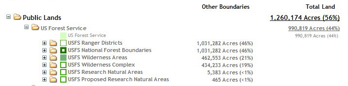
Note: Be aware that acreages in the right column are generally those owned by the entity, while those in the left column are special designations that are managed by the entity. These areas typically overlap a great deal, so the acreages are not cumulative. For example, the total acreage of U.S. Forest Service owned lands (right column) will likely be smaller than the administrative boundary of a national forest (left column), since national forest boundaries typically include privately owned parcels. Example: US Forest Service lands summary.
Notice -- Please Read
Map features in this application are not intended as a legal depiction of public or private surface land ownership boundaries and should not be used in place of a survey conducted by a licensed land surveyor. Similarly, map features, including conservation easements, do not imply public access to any lands.
The land status data displayed in this map viewer may not be complete and may contain errors in boundary locations and/or coding. The Montana Natural Heritage Program makes no representations or warranties whatsoever with respect to the accuracy or completeness of the data contained in this map viewer and assumes no responsibility for the suitability of the data for a particular purpose. The Montana Natural Heritage Program will not be liable for any damages incurred as a result of errors displayed here.
For questions about the data displayed here or to report errors, please contact the Montana Natural Heritage Program at (406) 444-3989 or mtnhp@mt.gov.