Status of Wetland and Riparian Mapping in Montana
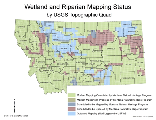
Click on the map for a larger image of the current mapping status.

Wetland and Riparian Mapping Progress-June 2019
2,445 USGS 24K Quads Mapped - 3,200,274 Total Acres MappedWetland Acres Mapped: 2,530,053
Riparian Acres Mapped: 670,221
Mapping Progress Documentation
Wetland and riparian acres represent the area mapped and classified as either wetland or riparian based upon photointerpretation of 1-m resolution aerial imagery. These acres do not necessarily represent actual on-the-ground conditions. Factors such as photo quality, scale, and environmental conditions at the time of photo acquisition can affect mapping accuracy. Additionally, digital wetland maps are static and do not reflect the dynamic nature of wetlands that are subject to drastic annual and seasonal fluctuations in size and distribution. Mapping with high resolution imagery, as required by the Federal Geographic Data Center Wetlands Mapping Standard, allows for the identification of smaller wetland areas compared to historic wetland mapping created from imagery at a coarser scale. The resulting increase in the wetland acreage mapped is a result of the greater detail provided by using high resolution imagery and does not necessarily reflect an increase in on-the-ground wetland acreage.Moreover, wetland acres presented as a result of mapping cannot be directly compared with historic estimates of wetlands; as such estimates of wetland acres are often based upon original land survey data or extrapolated from hydric soil maps, providing a simplified characterization of historic wetland extent.


